FAQ
The quality of our street environments is crucial to our health and wellbeing.
The Healthy Streets Index is an expert-designed spatial dataset that scores every street in relation to the Healthy Streets Indicators using a composite of key city-wide datasets. It provides a score between 0 and 100 for how healthy every street is to inform decisions about where we live, our travel routes and urban planning.
The Healthy Streets Index is the only dataset that offers a comprehensive scoring of urban environmental characteristics that account for both environmental and experiential qualities of a place. The Indexes for London, UK and Barcelona, Spain are publicly available.
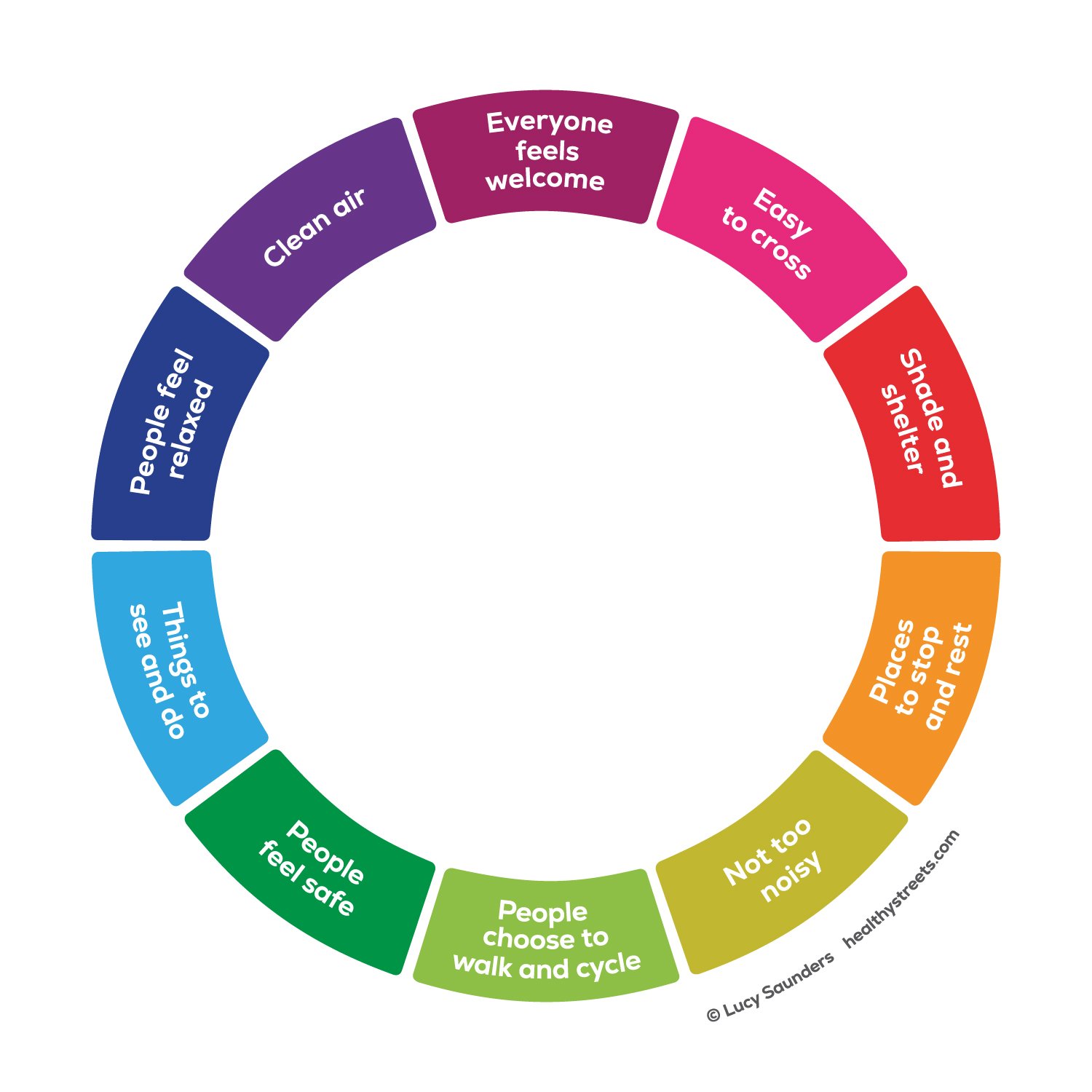
1. What is Healthy Streets?
Healthy Streets is a framework of 10 Indicators which describe the human experience of being on streets that we should be seeking to achieve a healthy, sustainable, welcoming environment for all.
To deliver improvements in these 10 Healthy Streets Indicators we need to make changes in many different sectors and at different levels – individual streets, neighbourhoods and city-wide. This collective of action to shape the design, management and use of streets around the needs of people is referred to as the Healthy Streets Approach.
Healthy Streets is being adopted in cities and regions around the world. Most notably London UK embedded Healthy Streets in all statutory strategies and it has been the framework for transport and street planning since 2018.
2. How can we measure how healthy a street is?
There are a range of different methods for measuring Healthy Streets. Each has its own purpose, value and limitations.
Healthy Streets Surveys ask the public for their perceptions of each Indicator on an individual street. This is subjective and resource intensive, it is usually used to assess opinions of individual street locations and convey public sentiments.
Healthy Streets Design Checks quantitatively score the physical layout of the street space between the buildings. This scoring is limited to a selection of physical criteria and does not directly assess the human experience of being on streets. It is primarily used by engineers and designers to identify opportunities for improving street designs.
Only one method has so far been developed that can provide a picture of Healthy Streets for all the streets across a large area or region, this is the Healthy Streets Index.
3. What is the Healthy Streets Index?
The Healthy Streets Index is a tool that shows the ‘healthiness’ of individual streets across a city or region at a glance.
The Index is composed of the factors we know have the biggest impacts on both human health and people’s experience of being on streets, walking and cycling.
The Healthy Streets Index gives a rating for every street in a city or region using a composite of key city-wide data sets.
The data selected for inclusion in the Index are the best available, robust, city-wide data sets that each describes a critical element of Healthy Streets. By combining and calibrating these data we gain a valuable insight into how each street performs in relation to the Healthy Streets Indicators overall.
4. What are the strengths of the Healthy Streets Index?
This is the only dataset that gives a Healthy Streets score for every street across a large geographical scale and reflects the role of street connectivity and land-use at the city-scale as well as details of the design and feel of the space on individual streets.
The context of each street within the city, town or region is of fundamental importance. The connectivity of the street within a wider network of streets, public transport provision and the land-use between the streets are important for understanding how healthy a street is. Unlike the other Healthy Streets measurement tools, the Index incorporates these contextual factors.
This Index includes the most accurate measures of noise and air pollution available plus a unique dataset of the available pavement/sidewalk space which is critical to streets being healthy, accessible and welcoming.
This is the most cost-effective way of grasping at a strategic level how healthy the streets in a place are. This data can help strategic decision makers identify what measures are needed and where, to make the whole place healthier and reduce inequalities within that place.
The Healthy Streets Index is applied consistently across different places so you can compare the healthiness of the streets in one place with another and you can compare individual streets in different cities.
5. What are the limitations of the Healthy Streets Index?
The Healthy Streets Index is able to show the basic fundamentals of how healthy streets are but it does not reflect the detail of each individual street which can influence people’s experience of that street.
The human experience on an individual street is subjective to an extent and is also influenced by details of how the street is designed and how it is being used at a particular moment in time. The Healthy Streets Index does not reflect this level of detail. Data that accurately captures the detail along all of every street in a town or city is currently not available for many elements of streets that can affect the human experience.
For example, cleanliness will influence people’s on-street experience but this is not included in the Index because there is no live dataset available.
6. What is a good score?
Most streets have been managed as spaces for the movement and storage of motor vehicles for many decades. They do not perform well against the Healthy Streets Indicators because they are not prioritising people’s basic health and accessibility needs when walking, cycling and spending time on streets. The purpose of the Healthy Streets Index is to help decision makers to prioritise improvements, at scale, which will change this.
Streets that are scoring below 30 are likely to feel hostile to people walking, cycling or spending time on them. Streets that are scoring over 70 are likely to feel amongst the best in that city although there will still be room for improvement.
7. Are streets that score the same in the Healthy Streets Index for different cities equally healthy?
Broadly speaking, yes. Comparability is ensured by using similar metrics and weighting them in the same way.
Healthy Streets is an absolute concept. Human physiology and the human body’s tolerance of harm and injury are the same whichever place those humans are. If a street is noisy, polluted, with a lack of safe space for walking or cycling and high volumes and speeds of motorised traffic it will get a low score to reflect the fact that it is not a healthy environment. It does not matter if this is one of the healthiest streets in a city, it will not get a higher score, the other streets in the city will just get an even lower score.
8. How can communities change the Healthy Streets Index for their street?
Improving the Healthy Streets Index score for a street requires action at every level. Some factors that contribute such as land use, traffic routing and street layout are managed at a municipal level and communities will need to engage with their municipality to champion change in these factors.
Traffic volumes and speeds have a big influence on the Healthy Streets Index because they hugely influence human health. There are also actions that everyone in a community can take to improve the healthiness of their streets. For example, by minimising their use of cars; walking, cycling and using public transport; and activating their streets with planting and street-based activities in suitable places.
Activities by groups and individuals will make the street a healthier place but are unlikely to show a shift in the Healthy Streets Index score. This is because the Healthy Streets Index score incorporates some bigger factors that are difficult to shift on a single street basis such as connectivity of streets and land use.
9. How does the Healthy Streets Index reflect the needs of disabled people?
Disabled people, like all people, need to live in a healthy environment in which they can easily travel actively, socialise and connect with other people. The Healthy Streets Index reflects these fundamental basic needs that all people have. Disabled people often have an even greater need for clean air, low noise, wide pavements and dense, well-connected street networks than the wider community due to health conditions related to their disability.
In addition to these fundamental needs there will be details of how individual street are designed and used which can make streets more challenging to use, and even exclude some people from certain streets. These include broken and uneven pavements, street clutter, mis-laid or missing tactile paving and lack of accessible crossings on desire lines. Even though it is important to people with certain mobility and sensory impairments, this level of detail has not been compiled into a city-wide data set and is therefore not included in the Healthy Streets Index. This highlights the importance of cities actively working towards collecting these types of data to enable digital representations of the built environment that are inclusive across all groups.
10. I think the Healthy Streets Index is wrong for my street, how can I get it changed?
The Healthy Streets Index gives a broad indication of how healthy the street environment is and should show where there are significant differences between streets. The Healthy Streets Index draws on the latest available city-wide datasets. If there has been a bold change to your street in recent months or years (depending when the relevant data-set was compiled) this may not be reflected in the Healthy Streets Index. For example, if your street has recently been closed to through-traffic that could have had a big impact on how healthy the street is. That will be reflected in the Healthy Streets Index when it is updated with the most recently available data sets.
11. Is the Healthy Streets Index a Walkability score?
The Healthy Streets Index gives a broad indication of how healthy the street environment is. This includes factors that are often not included in walkability scores such as air quality and noise. Some factors that are very important for walkability are included such as the width of the pavement and the level of traffic.
However there are other details that affect how walkable the streets are which are not included because the data is not available at the city level. For example, environments are more walkable when they are visually engaging with interesting building facades that change frequently, well maintained planting, human activity on the street. These factors have not been quantified in a robust and comprehensive manner to be viable to include in the Index at this point.
12. Why does a street which does not feel easy to walk still get a reasonable score?
The Healthy Streets Index is a composite of multiple factors and while one may bring the score down, another may bring it up. For example, a street may have very narrow footpaths which bring its score down but also low levels of traffic which bring its score up. It may not feel comfortable to walk on the narrow footpath but its score may not be especially bad because the lower levels of traffic make it quieter, safer and easier to cross. If you find yourself on a street and you are puzzled as to why it got an ok score even though it doesn’t feel good to you for walking then it is likely due to one of the following:
There are features that make the street good for cycling which have brought the score up
There is cleaner air, lower noise or reduced traffic which bring the score up
The factors that make this street not feel good for walking have not been included in the Index e.g. the footpath is cluttered with tables and signs
13. How often is the Healthy Streets Index updated?
The Healthy Streets Index can be updated when new city-wide data are available. Some of the data included are unlikely to change much from year to year such as land-use mix and density. Some data could change significantly if there is a major policy shift covering a large area e.g. road user charging or speed limit reduction.
However, a major shift in the Healthy Streets Index scores across a whole city or region are unlikely to occur over a timeframe of a few years, even in very dynamic places. We therefore revisit the data every five years to assess whether it would be of value to update the Index.
14. What is the Healthy Streets Index used for?
The Healthy Streets Index has several core uses:
Strategic planning
The Healthy Streets Index provides a robust and standardised street rating that enables city-wide planning of improvements and the creation of active travel networks. In particular it is useful for
Ensuring continuity of healthy routes for people walking, cycling and using public transport
Identifying and addressing inequities between streets and neighbourhoods
Assessing whether investments are being delivered where they are most needed
Assessing whether policies will have an impact at a significant scale
Setting ambition and tracking long-term change across the city or region
Route Planning and Navigation
The Healthy Streets Index data can be integrated into routing engines to prioritise routes that provide healthier environments and are safer to walk, cycle or run in.
Property and Real Estate
Managers and agents for property and real estate can find the Healthy Streets Index to be a valuable additional tool when communicating with their clients about the quality of the local environment.
15. Which cities have a Healthy Streets Index?
There is a publicly available Healthy Streets Index for Greater London, UK and Barcelona, Spain. If you want the full datasets for these cities email contact@healthystreets.com and this data can be provided for a fee.
16. How do I get a Healthy Streets Index for my city or region?
The specialist team who produce the Healthy Streets Index will first meet with you to discuss what data is available for your city or region. If there is sufficient data to enable us to produce a Healthy Streets Index we will assess the datasets and generate a quote for producing an Index based on the amount of time it will take us to process it. If there is insufficient data we will advise you that at this time it is not possible to produce a Healthy Streets Index for your city or region.
17. Can I produce my own Healthy Streets Index?
The Healthy Streets Index is produced by a specialist team who ensure consistency between the Indexes of all the cities by using a standard methodology. If you want an Index for your city you can commission this team to produce it for you. If you have data processing skills then you can reduce the cost by contributing to the data processing, overseen by the specialist team.